Ben Lomond resident Gerald Hatcher is an oceanographic engineer for the United States Geological Survey Pacific Science Center team that is responsible for the mapping of the ocean floor and countless sub-surface tasks throughout the Pacific Ocean.
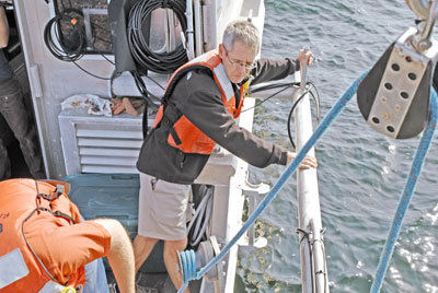
On Nov. 9, Hatcher invited a Press-Banner reporter for a cruise on the Monterey Bay aboard their heavily-equipped research vessel, Parke Snavely, while the team calibrated a new inertia sensor. The equipment will assist the team in accurately controling their readings as the boat bobs and rocks on the water to within a few centimeters.
The USGS team — based in Santa Cruz — has spent countless hours mapping the strata and substrata of the Pacific Ocean’s sea floor, looking for fault lines and inconsistencies in the data.
“We are responsible for mapping and gathering data from Alaska all the way out to Hawaii,” Hatcher said. “We track sea floor movements and tsunami data that would otherwise go unnoticed.”
The team maps particular areas of the seafloor selected by research scientists to answer a specific question — such as how far offshore does a fault zone extend.
The oceanographic team joined with land-based researchers and scientists earlier this year at the geological survey’s western headquarters in the old Wrigley building off Mission Street in Santa Cruz.
The USGS Pacific Science Center moved into the facility after 15 years at University of California, Santa Cruz, with a far smaller presence.
The Parke Snavely is a sophisticated vessel. The equipment aboard the ship lets the team use sonar and three-dimensional graphing technology to track the sea floor’s movements and composition, as well as to gather data.
The ship is captained by Jenny White, who often is required to maneuver the ship over long and straight swaths as the crew collects information.
“This job can be really exciting and really dull all at the same time,” said White, as she twisted the ship in a figure-eight pattern for the engineers. “We can spend whole days driving like a lawn mower in seemingly never-ending patterns. I have to keep this 35-foot boat on a line that doesn’t deviate by more than 3 meters. It becomes nerve-racking after a while.”
While the Parke Snavely is capable of speeds in excess of 35 knots — or just over 40 mph — the majority of the trip was spent at 6 to 8 knots because the equipment cannot take accurate readings at higher speeds.
“The USGS Pacific Science Center does much more than map the sea floor,” Hatcher said. “We have researchers that are looking at shoreline erosion, sea level rise, marine sediment transport, effects of dam removal and habitat restoration.”
Hatcher and fellow ocean engineer David Finlayson are a part of the team. When the USGS conducted the mapping of the United States on land, it opened opportunities for further exploration and understanding of our county.
“An entire month’s cruise of sea floor mapping data might have been 4 gigabytes of data,” Hatcher said. “Now, depending on the system we’re using, we can collect that same amount of data in just five minutes. The detail with which we can see things on the floor has increased just as dramatically.”
The data is processed on the boat with dedicated computers with specialized software to eventually be made available, so other scientists, government agencies, and the public can use it.


