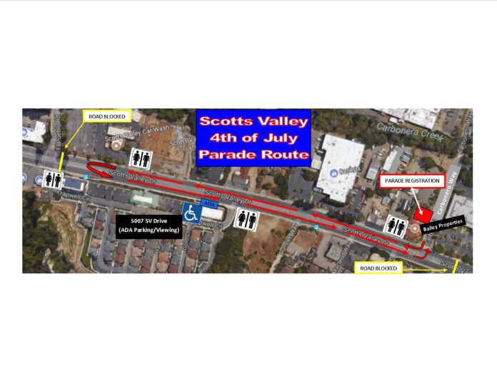
The City of Scotts Valley annual 4th of July parade will once again be held on Scotts Valley Drive from 3 p.m. to 4:30pm. The route will be the same as last year’s (shown on the attached map). The parade route starts at the intersection of Scotts Valley Drive and Carbonero Way, heads north towards El Pueblo Road and loops back to Carbonero Way where it ends.
The disabled persons’ parking and viewing area has changed locations. This was done in response to concerns voiced after last year. The parking/viewing area will be set up at 5007 Scotts Valley Drive (shown on the map).
Parade participants can pre-register by filling out the application form found on the City of Scotts Valley website http://www.scottsvalley.org All parade participants must check in at the registration area at Bailey Properties (corner of Scotts Valley Dr. and Carbonero Way). Registration begins at 2pm. Participants will receive participation ribbons and directed to designated staging areas. Please note the staging areas have changed slightly this year, and participants will be directed accordingly (Refer attached map).
Due to the damaging of electronic equipment and classic cars, water spraying between parade participants and the crowd is not allowed. Please be respectful of other people and their property. Additionally, please be respectful around the horses/animals: slow down and no loud sudden noises.
ROAD CLOSURE – Scotts Valley Drive will be closed from just south of Carbonero Way to the intersection of El Pueblo Road. NOTE: El Pueblo Road will still be accessible. Scotts Valley Drive will be closed from 2pm to 5pm.


