Some of us live on sandstone; some of us live on granite; and some of us live on marble and that makes a difference, according to geologist Jeff Nolan. He and other natural science experts spoke recently at a public planning meeting for the San Lorenzo Valley Water District’s Felton watershed property.
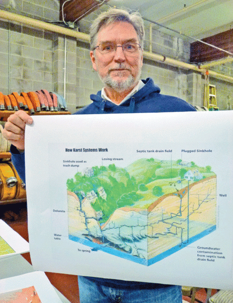
“Marble is different from all other rock types because it dissolves in rain water,” said Nolan.
The water flows through the rock and forms channels which dissolve it, creating what is called a Karst topography.
In two other types of Ben Lomond Mountain topography, called granular (sandstone) and crystalline (granite), water flows between individual grains and grains don’t dissolve.
Working with the San Lorenzo Valley Water District on the mountain, Nolan will be looking for open fissures and underground caves that serve as conduits for ground water.
“They capture surface water, store it, and let it out in surface springs. They are important water supplies,” he said. “We’ll locate areas of karst, so we can look at the water sources for the aquifers and make sure they’re not contaminated. I’ll be doing some remote sensing and doing some field work up there and mapping all the areas of marble.”
Remote sensing is Nolan’s first step in his hunt for marble. Using aerial photographs and lidar (laser) imaging, he will be looking for sink holes, indicative of a karst topography.
The study will last approximately six months and field work will include a month on Ben Lomond Mountain.
“I’m going wherever I think the marble might be,” the geologist said.
The rock makes up only 10 percent of Ben Lomond Mountain’s topography.
His work will take him off-trail to do some old-fashioned bushwhacking.
Focusing on areas around Fall, Bull and Bennett creeks, Nolan will map sinkholes, which can go down several hundreds of feet, and outcrops of marble.
“That was what they used to quarry for all the cement that was made here 100 years ago,” he said. “Lime is made out of marble. Marble starts out as limestone, but it is recrystallized by the earth’s heat and pressure. Minerals don’t change, just the form. You quarry the marble and then you break it up, then you put it in the kilns and bake it. Then it turns into lime.”
After Nolan’s final report, SLVWD will use this information to do additional work to see what water sources are feeding the aquifers that they use and take steps to protect them if necessary.
In the past Nolan has mapped the University of California, Santa Cruz campus for the Geologic Hazards Evaluation and all the karst areas, plus Pogonip for the resource study that was done before the City of Santa Cruz acquired it.
The Water District’s environmental analyst Betsy Herbert spearheaded the meeting, introducing the Felton watershed property. Other panelists included fisheries biologist Don Alley, State Parks ecologist Portia Halbert, and historian and author Frank Perry, who has led several watershed walks for my environmental education grant from the District.
Perry has curated the special exhibition “Crystals, Caves, and Kilns,” now at the Santa Cruz Museum of Natural History, which explores the natural and cultural history of limestone, lime, and marble in the Felton and Santa Cruz area. The exhibition will move to the San Lorenzo Valley Museum in Boulder Creek in spring 2014.
– Carol Carson, M.Ed., is a writer, naturalist, and educator.

