As a second round of storms hit first Northern California, then Southern California this week, several forecasters were declaring the four-year drought was finally over, at least for the north.
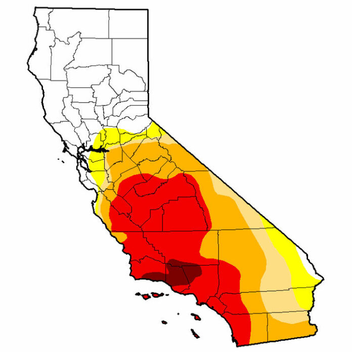
The National Oceanic and Atmospheric Administration’s weekly national Drought Map, released this week showed that drought conditions no longer existed in the the Bay Area, the Santa Cruz Mountains and the Monterey Bay area.
A dramatic map comparison to three years ago showed the most severe areas of drought – which once had covered most of the state – had been reduced to a small area north of Los Angeles. The Southland was to get more rain this weekend than last weekend, so next week’s map could look very different.
Reservoirs were overflowing in the north, such as Loch Lomond and the Lexington Reservoir, but large reservoirs in the south Central Valley and San Diego county were filling more slowly, with drought conditions persisting in the southern Central Valley.
Daniel Swain, a climate scientist with the Institute of the Environment and Sustainability at the University of California, Los Angeles, wrote this week that “from a surface water perspective, that is, water present in rivers, lakes, and man-made reservoirs, the drought may effectively be over across much of Northern California.”
He cautioned, however, that severe drought conditions persist across much of Southern California, “and even in northern California groundwater aquifers remain severely depleted, as much of the heavy rains wash into the rivers and the ocean before the water can be absorbed into the supersaturated ground.
For these reasons, Gov. Jerry Brown, who declared the drought emergency in 2013, is likely to hold off on any formation declaration about the end of the drought until the spring or summer. State hydrologists report that a rule of thumb is that a water year must be 150 percent of normal following dry years to even consider lifting drought restrictions.
How close are the Santa Cruz mountains to that? Unless it stops raining, this year is on a pace to match heavy rainy seasons of 2006 and 2020, but likely to fall short of the century-high mark of 115 inches in 1982.
In Ben Lomond, as of Tuesday, Jan. 17, 54.69 inches of rain had fallen in the current water year, which began Oct. 1. That is nearly 4 inches above the annual average, and more than double the amount of rain at this time last year.
CalFire reported Tuesday that 48.94 inches of rand had fallen in Felton, just shy of last water year’s total of 51.21.
The San Lorenzo Valley communities and Scotts Valley all reported approximately 20 inches of rain in the first two weeks of January.


